

4 ways augmented reality helps you spot ships like a pro
You're standing on a ferry deck, or leaning on a harbour railing with a coffee, and a ship slides into view. It's got a distinctive hull, an interesting flag, maybe a name you can just about make out through binoculars. The question hits immediately, “what is that, and where's it headed?”
For years, answering that question meant opening a map app, zooming around, and matching a dot to the ship in front of you. Augmented reality (AR) skips all of that. Point your camera at the water and the ship basically introduces itself.
What is maritime augmented reality?
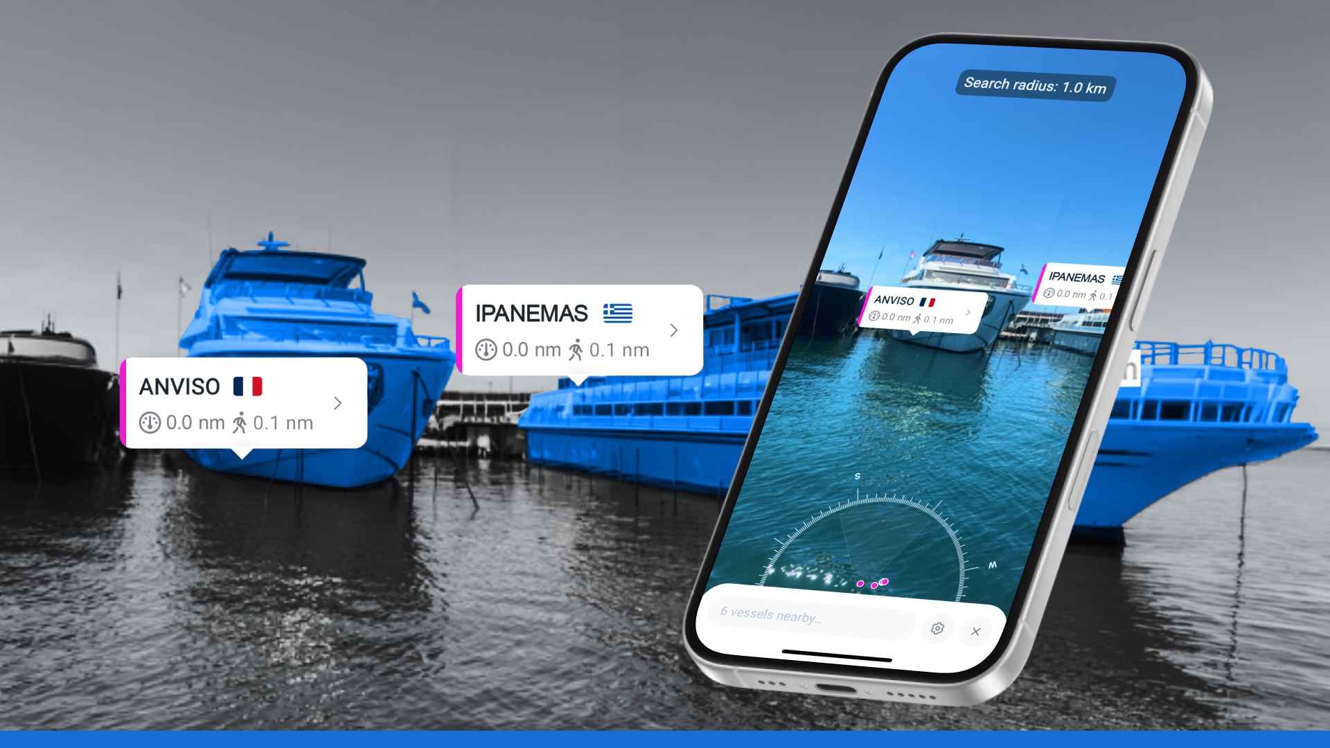
Think of it as a name tag generator for ships. Maritime augmented reality overlays live vessel data, name, flag, distance, straight onto your camera view, and anchors that label to the exact spot where the vessel is sitting in the real world.
The data comes from AIS (Automatic Identification System), a signal that vessels broadcast constantly with their identity, position, speed, and heading. Your phone already knows where you are and which way you're pointing. AR just does the math to connect the two, so the label sits right on top of the ship instead of floating uselessly on a flat map.
No more matching or zooming. Just point and know.
How does maritime augmented reality work?
Here's the fun part – what's happening behind that little floating label is a surprisingly neat piece of engineering:
- Your phone figures out where you are and where you're looking. GPS gives location and compass gives heading.
- It calculates the bearing and distance to every nearby vessel broadcasting AIS data.
- Each vessel gets a label anchored to its real bearing, so as you swing the camera left or right, the label moves with the ship, not with the screen.
- Busy harbour? No problem. If there are more ships than the screen can handle, they get grouped into a single tappable cluster instead of turning into visual soup.
- Ship out of frame? Arrows or a little radar dial point you in the right direction so you know which way to turn.
- Tap a label and get the details. That might be a quick ID or a deeper profile with voyage history.
It's a lot of moving parts working together, so you can casually go "oh, that's a bulk carrier from Rotterdam" without lifting a finger.
What are the benefits of augmented reality?
A few reasons this feature has a way of turning casual onlookers into repeat users:
- It rewards curiosity instantly: No delay between "what is that" and knowing the answer.
- It's social: Screenshotting a labelled ship to send to a friend or family member is oddly satisfying.
- It works without any nautical knowledge: You don't need to know what a bulk carrier is versus a tanker beforehand. The app tells you and you learn as you go.
- It makes ordinary moments feel a little more special: A ferry crossing, a coastal walk, a window with a harbour view – they all get a bit more interesting when every ship has a name and a story attached.
Who uses augmented reality in the maritime world?
1. Ship spotters
For the dedicated hobbyists who camp out at canals, river mouths, and port entrances with a camera, AR is basically a superpower upgrade. Instead of snapping a photo and looking up the vessel later, spotters can confirm the name and flag in real time, mid-shot, without breaking focus or missing the moment.
2. Coastal residents
If you live near a harbour, river mouth, or shipping lane, you've probably wondered about a passing ship more times than you can count. AR turns that idle curiosity into an instant, satisfying answer, right from your kitchen window or your morning walk.
3. Cruise and ferry passengers
There's something inherently fun about being able to point your phone at a distant ship on the horizon and immediately know what it is. It's the kind of feature that turns a quiet sea crossing into an active little game, and it's exactly the sort of thing people end up sharing with everyone back home.
4. Casual boaters who just like knowing what's around
For recreational sailors out on the water, AR is a nice, easy way to satisfy curiosity about nearby traffic (it's a fun add-on to keeping a proper lookout, not a substitute for it).
What does a day with augmented reality look like?
Picture a Saturday afternoon ferry crossing. Someone in the group spots a hulking container ship in the distance and asks the obvious question, “what is that thing?”
Normally, that's where the conversation stalls. Nobody actually knows, and nobody's going to open a spreadsheet of vessel names to find out. With AR, someone just lifts their phone, and within a couple of seconds there's a name, a flag, and a distance floating right on top of the ship. Suddenly everyone on deck is playing a mini identification game, comparing notes on which vessel is heading where.
That's really the whole pitch in one scene. It's not about mastering maritime data. It's about turning a passing curiosity into a shared, slightly delightful little moment, without any effort at all.
3 quick facts on maritime augmented reality
- Search radius can typically be adjusted up to around 50 km, so you can widen your net if the water looks quiet.
- Vessels need to be actively broadcasting AIS to show up. No signal or label, even if you can see the ship with your own eyes.
- The busier the waterway, the more ships you'll see clustering on screen, which is honestly part of the fun in a place like a strait or a major port approach.
Frequently asked questions
What is maritime augmented reality?
It's a feature that overlays real-time vessel information, like name, flag, and distance, directly onto your phone's camera view, so you can identify ships just by pointing at them.
How does it know which ship is which?
It uses AIS data, the signal vessels broadcast with their identity and position, combined with your phone's GPS and compass to match the right label to the right ship.
Do I need to know anything about ships to use it?
Not at all. That's part of the appeal. You point, you learn, you move on with your day slightly more informed than before.
Why doesn't every ship show up?
Only vessels actively broadcasting AIS will appear. If a ship isn't transmitting, or you're outside your search radius, it simply won't show.
Who's it made for?
Anyone who's ever looked at a ship and wondered what it was. Ship spotters, coastal residents, ferry and cruise passengers, and curious boaters all get a kick out of it.

See why the most successful traders and shipping experts use Kpler
See it. Tap it. Identify it.
.jpeg)